Nature-related Data Report
The Network for Greening the Financial System (NGFS) releases a report on nature-related data, aiming to summarize the sources, indicators, and applications of nature-related data in risk management.
The NGFS believes that nature-related data can be used for natural risk assessment, helping regulatory agencies identify the main factors causing ecosystem loss and analyze their impact on the economy.
Related Post: TNFD Releases Global Natural Data Report
Role of Nature-related Data
Nature-related risks are more complex than climate risks due to the diversity and non-linear characteristics of ecosystems, as well as their strong geographic specificity. Therefore, natural risk assessment needs to be based on local data and local models, and nature-related data typically includes location-based information to measure nature-related risks.
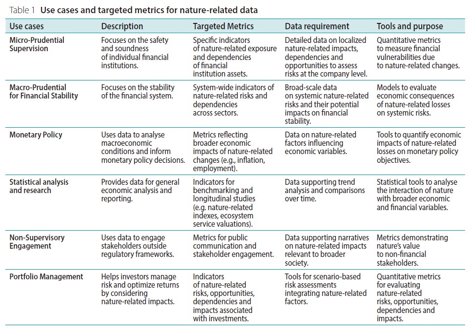
For regulatory agencies, at the micro level, nature-related data can measure the degree of natural risk exposure of individual institutions, and at the macro level, it can measure the systemic risk of the entire economic system. Nature-related data can also play a role in monetary policy formulation, investment portfolio management, and other aspects.
Nature-related Data Indicators
The NGFS screens nature-related data indicators under the Taskforce on Nature-related Financial Disclosures (TNFD) framework and develops the following core standards:
- Prioritize land use change: Land use changes caused by agricultural, forestry, and industrial activities are major driving factors for natural degradation, biodiversity loss, and water resource pressure, and needs to be given priority consideration.
- Cover the relationship between climate and nature: There is a correlation between climate change and natural change, for example, water resource pressure has an impact on temperature change, and temperature change can also affect water resource pressure.
- Emphasize geographical location: Nature-related impacts have regional characteristics, and screening needs to consider different geographical spaces.
- Choose multiple indicators: Different indicators can complement each other and comprehensively reflect the state of the ecosystem.
- Consider data availability: Focusing on open-source data to improve the accessibility of indicators and facilitate subsequent applications.
Based on the above criteria, the NGFS selects approximately 50 out of 146 natural indicators, covering multiple dimensions from biological status (such as land use, water resource pressure) to financial impact and opportunities (such as nature-related income, proportion of green investment). For regulatory agencies, the screened indicators can be used to construct an efficient natural risk assessment framework.
Nature-related Data Challenges
The NGFS believes that the application of nature-related data faces the following challenges:
- Data quality and availability: Nature data often requires on-site sampling and is subject to geographical limitations. Some ecosystem service assessments may lack accurate geospatial data, which can affect the effectiveness of risk assessment.
- Application effect of cutting-edge technology: Machine learning and deep learning models can recognize the statistical relationship between input and output information, but their application requires high data accuracy. When the data quality is low, it may simplify the analysis process.
- Ecosystem valuation methods: Common ecosystem valuation methods usually assign the same value to the same land type in different locations, but ignore the characteristics of different spaces, which may lead to inaccurate valuation of small areas.
The NGFS believes that the above challenges can be applied in the following ways:
- Promote localized data generation: Public and private sectors collaborate to develop natural data roadmaps and obtain local data.
- Promote data management practices: Establish open-source databases to improve data systematization and transparency.
- Fill the gap in biological data: Classify and apply statistical methods to process data gaps, simulate the complexity of biological environments using geographic images, and target investments in areas with significant data gaps.
Reference: